


Hema 4WD Maps Australia
0.00.00 Reviews
App Specs
- Version
- Varies with Device
- Updated On
- License
- $69.99
- Downloads
- 10,000+
- Developer
- Hema Maps Pty Ltd
- Categories
- Maps & Navigation
- Platform
- Android, iOS
Screenshots
 Analysis by AppCompare
I came away from Hema 4WD Maps Australia with a fairly clear impression: this is a specialist navigation tool for people who treat the route as part of the adventure, not simply as a line between two towns. It sits in the Maps & Navigation category, but it is aimed at a much narrower job than a normal phone map. The appeal is the promise of preparing for remote four-wheel-drive travel with offline mapping rather than relying on an ordinary road app to understand an off-road trip.
That focus is both its greatest strength and its biggest warning. If I were planning a weekend on marked highways, I would not choose a paid specialist app like this as my everyday navigator. If I were preparing for a remote Australian drive where mobile coverage might become unreliable and route context matters, I would take it much more seriously. The important question is not whether it replaces Google Maps or Apple Maps. It does not. The question is whether its off-road purpose justifies adding another navigation tool to your phone.
What makes the app different from an ordinary map
Hema Maps Pty Ltd has built this app around four-wheel-drive travel rather than general commuting. That distinction changes how I think about it. A mainstream navigation app is excellent at getting me to a street address, finding a business, estimating a city journey, or rerouting me around traffic. Those apps are designed for connected, conventional travel. A dedicated 4WD map is more useful when the destination is a track, a campsite, a remote crossing, or a long route where the surrounding terrain is part of the decision.
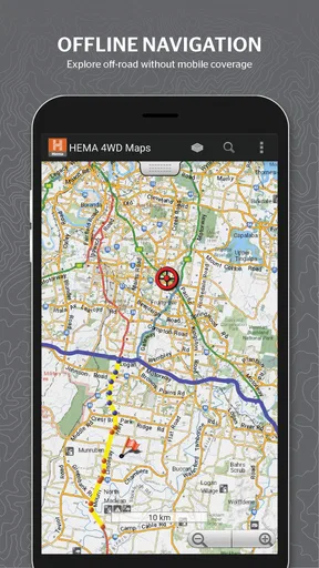
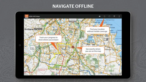
The store summary describes it as an offline map for off-road adventures, and that is the right lens through which to judge it. Offline access is not just a convenience in this setting. It can change how confidently I plan a route before leaving coverage. I can think about the journey as a complete trip rather than assuming that every turn will be supported by a live connection.
I also like that the app does not try to be everything for everyone. Its identity is clear: Hema 4WD Maps is for Australian four-wheel-drive navigation. That makes it easier to decide whether it belongs on my phone. The app is not competing mainly on restaurant search, urban traffic information, or public transport directions. Its value comes from its relationship with remote travel.
The developer is Hema Maps Pty Ltd, a name closely associated with Australian touring and off-road mapping. The app was released on March 17, 2020, and its presence on the store has grown to over ten thousand installs. Those details do not prove that every route will suit every vehicle or trip, but they do place the product as a focused tool rather than a mass-market navigation replacement.
Offline planning is the feature I would use first
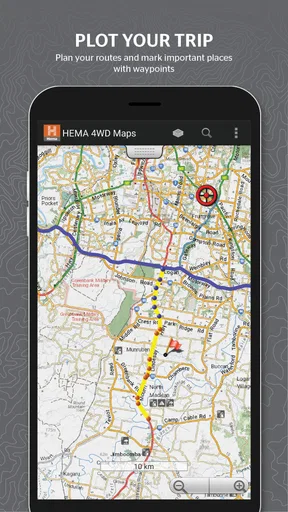
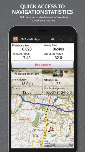
My first practical step with an app like this would be preparation at home, while I have a reliable connection and enough time to think. I would look over the complete journey, identify the remote portions, and make sure the relevant map material is ready before driving away. That workflow is more important than simply opening a map after the trip has started.
Worth Reading Before You Choose

EA SPORTS FC Mobile 26 Is a Bigger Football Game, but It Takes Time

Flipboard Shows What News Apps Must Do Beyond the Feed

Switching to Android Auto Means Rethinking Your Driving Routine

Google Calendar Makes a Crowded Week Easier to Manage

Ludo King Makes the Most of the Minutes Between Plans

Baby Panda World Brings Quick Play to Modern Phones, but Its Game Library Feels Busy
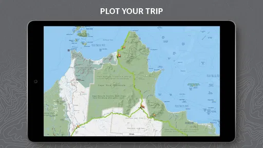
A useful habit is to divide a trip into sections instead of treating it as one huge route. I would check the approach roads, the off-road section, likely stopping areas, and the return or alternate exit. This makes it easier to notice where a route becomes isolated and where a detour could create a much bigger problem than it would in town. It also gives me a mental picture of the trip if the phone becomes difficult to use while moving.
There is a subtle trade-off here. Offline mapping can make a remote trip more dependable, but it does not remove the need for preparation. A downloaded map does not automatically tell me whether a track is suitable for my vehicle, whether conditions have changed, or whether a crossing is safe on a particular day. I would use the app to understand the route and maintain orientation, not as permission to ignore local signs, closures, weather, or common sense.
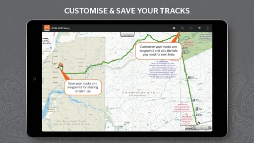
For that reason, I would prepare a second layer of information as well. I would write down key junctions, keep an offline note of the intended route, and carry a backup navigation method. That is not a criticism unique to this app; it is simply the responsible way to use a phone for remote travel. The app can reduce dependence on a signal, but the phone itself still depends on battery, a readable screen, and a working device.
How it fits into a realistic trip
Imagine I am leaving for a long weekend with a four-wheel-drive vehicle, heading from a populated area toward a remote campsite. On the first part of the journey, I might still use a familiar road-navigation app because it is convenient for fuel, traffic, and town stops. Before the sealed road ends, I would switch my attention to Hema’s mapping and check the planned off-road section.
At a junction, the benefit is not merely seeing a blue line. I want to understand whether I am still following the intended track, how the route relates to nearby alternatives, and what lies ahead before I commit to a turn. In a remote area, a wrong turn can cost more time and fuel than it would in a suburb. Looking ahead while stopped gives me a chance to make a decision before the vehicle is moving again.
Another useful workflow is to use the app as a pre-trip discussion tool. If I am travelling with friends, I can review the route with them before departure and agree on the sections that deserve extra attention. That helps avoid the common problem of one person assuming the route is a simple drive while another expects a demanding off-road day. A map designed for this kind of travel is valuable partly because it supports better decisions before the wheels turn.
I would also avoid relying on a phone mounted where glare, dust, or vibration makes the display hard to read. The app may be useful for quick checks, but I would still stop safely before studying a complicated section. That sounds obvious, yet it is one of the practical differences between using a map in a city and using one on an isolated track.
The strongest case for choosing it
The strongest case is concentration. Instead of forcing a general-purpose map to understand an off-road journey, I can use a product built around that type of travel. The app’s purpose makes it easier to plan with the right questions in mind: where does the route go, what happens after the next junction, and how will I stay oriented when the normal assumptions of connected driving disappear?
I also see value in using it alongside, rather than instead of, a normal navigation app. The two tools have different jobs. A mainstream app is usually better for urban arrival details and live road information. Hema 4WD Maps Australia makes more sense for the remote and exploratory part of the journey. That combination may sound less elegant than using one application for everything, but it is more realistic for a mixed trip.
The app is priced at $69.99, so I would not describe it as an impulse download. The cost demands a clear use case. For someone who regularly plans Australian four-wheel-drive trips, the price can be easier to justify because the app is aimed at a specific need. For someone who takes one occasional camping holiday and already owns detailed paper maps or another dependable navigation setup, the purchase requires more thought.
The Everyone content rating is reassuring for families and mixed-age travel groups, although the rating is not a measure of off-road difficulty. A family can use the app, but the adults still need to decide whether a route is appropriate for their vehicle, experience, fuel range, weather conditions, and passengers.
Where the experience needs caution
The main weakness is that a specialist map can create a false sense of completeness. Seeing a route on a screen may feel more definite than the real world. Tracks change, access can vary, and a line on a map cannot replace current local knowledge. I would be particularly careful about treating every visible route as a promise that it is open, easy, or suitable for my particular vehicle.
There is also a learning curve in moving from ordinary navigation to off-road planning. In town, I can often follow turn-by-turn instructions without thinking much about the wider map. Remote travel rewards the opposite habit. I need to understand the broader route, watch for decision points, and keep track of where I am even when the next instruction is not immediately obvious. Someone expecting a completely hands-off driving assistant may find this less comfortable.
The price adds another kind of friction. At $69.99, this is a deliberate purchase, not a casual experiment. I would want to install it well before departure, explore the relevant areas, and decide whether its mapping approach suits the way I travel. Buying it on the morning of a trip would be poor planning, particularly if I have not tested the phone, storage, charging setup, and offline workflow.
I would also be careful about confusing offline maps with full offline support for every travel need. Even when the map itself is available without a connection, services that depend on current information may not behave in the same way. I would plan fuel, accommodation, emergency contacts, weather checks, and vehicle recovery arrangements separately. This app can be one part of a safety-minded setup, not the entire setup.
Who should use it, and who should skip it
I think it is best suited to Australian four-wheel-drive owners, touring couples, camping groups, and experienced travellers who regularly leave major roads. It also makes sense for someone who prefers to study a route before departure and wants a dedicated map rather than adapting a city-focused application to an off-road trip.
It is less convincing for a person who mainly drives in cities or between regional towns. If my usual navigation needs are finding shops, avoiding traffic, locating addresses, or receiving live directions, a standard map app will probably be more convenient. I would also hesitate if I only take an occasional short trip and already have a trusted offline navigation system, printed maps, and a well-tested vehicle setup.
Beginners can still benefit from it, but I would not recommend using the app as a substitute for off-road experience. A newcomer should travel with someone knowledgeable, learn how to read the route before departure, and treat the map as an aid to judgement. The best result comes when the driver understands the environment rather than blindly following the screen.
One practical tip is to test the entire workflow on a familiar route first. I would check how quickly I can find the map area, how clearly I can identify a junction, and whether the phone remains usable in the vehicle. A short test can reveal more than reading a description because it shows whether the app fits my habits and equipment.
Another is to plan around stopping points rather than trying to inspect the map continuously while driving. I would review the next section before leaving a safe stopping place, then use brief checks only when necessary. This reduces distraction and gives the map a supporting role instead of turning it into a demanding second driver.
A third is to keep the trip plan understandable to another person. If I am travelling in a convoy or leaving an itinerary with someone at home, I would record the broad route and expected checkpoints separately. That makes the journey easier to discuss and provides useful context if plans change. The app can help me make that plan, but I would not make the plan exist only inside the phone.
My final recommendation
My verdict is positive but deliberately narrow. Hema 4WD Maps Australia is worth considering when offline, Australia-focused off-road planning is central to the trip. Its dedicated purpose gives it an advantage over ordinary navigation apps once the journey moves beyond familiar roads, and its strongest value appears before and during careful route decisions rather than in everyday urban driving.
I would recommend it to a regular 4WD traveller who is willing to prepare properly and pay for a specialist tool. I would not recommend it simply because someone wants another map on their phone. The $69.99 price is substantial enough that occasional campers should compare it with their existing setup first.
In my experience, the right way to use this app is as the navigation centre for the off-road portion of a broader travel system: prepare offline, study the route while stopped, carry backup information, and never treat the displayed track as a guarantee of current conditions. Used with that discipline, Hema 4WD Maps Australia can be a genuinely useful companion for remote Australian adventures. Used as a magical replacement for preparation and judgement, it is the wrong tool.
Pros
- Detailed 4WD tracks
- campsites
- and remote-area points of interest
- Works offline after maps are downloaded for trips without mobile coverage
- Includes useful terrain
- access
- and trip-planning information
- Covers popular Australian off-road destinations and regional tracks
- Helpful for planning routes beyond standard road-navigation apps
Cons
- Some map areas or features may require a paid purchase
- Track conditions can change
- so information may not always be current
- Offline downloads can consume considerable storage space
- Remote routes may lack detailed turn-by-turn navigation
- Coverage and accuracy can vary between Australian regions
FAQs for Hema 4WD Maps Australia
What is Hema 4WD Maps Australia used for?
Hema 4WD Maps Australia is designed for four-wheel-drive touring, camping, and off-road exploration across Australia. It provides detailed maps, tracks, travel information, and points of interest intended to help drivers plan trips beyond sealed roads. The app is especially useful for locating remote routes, campsites, fuel stops, and attractions while exploring regional and outback areas.
Does Hema 4WD Maps Australia work without mobile reception?
The app is intended to support travel in remote Australian areas where mobile coverage can be unreliable or unavailable. However, you should download the required map data and trip information before leaving reception. Offline performance may depend on the map package, device storage, and GPS availability, so it is important to test downloaded maps in advance rather than relying entirely on an internet connection.
Is Hema 4WD Maps Australia suitable for beginners?
Yes, the app can be useful for both newcomers and experienced four-wheel-drive travelers. Its mapping and trip-planning features make it easier to identify off-road routes, campsites, and nearby facilities. Nevertheless, beginners should not treat the app as a replacement for proper preparation, vehicle recovery equipment, local advice, weather checks, or responsible navigation, particularly when traveling through isolated terrain.
What types of information and destinations are included?
Hema 4WD Maps Australia focuses on information relevant to Australian touring and off-road travel. Depending on the selected map coverage, users may find 4WD tracks, national parks, campsites, caravan facilities, fuel locations, scenic destinations, and other travel points of interest. Coverage and detail can vary between regions, so checking the available map area before purchasing or downloading is recommended.
Can I rely on the app as my only navigation tool?
You should not rely on Hema 4WD Maps Australia as your only navigation or safety resource. Digital maps can contain outdated information, GPS limitations, access changes, or incomplete details, especially on remote tracks. Carry a backup map, maintain offline copies of important information, tell someone about your route, and check local conditions, closures, permits, and weather before starting your journey.


